
IRESELAND: PAST, PRESENT AND FUTURE
Etymology:
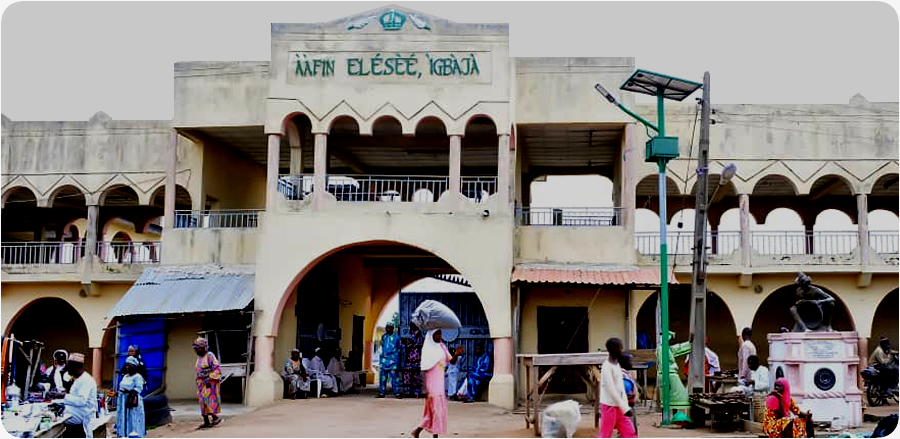
Ireseland is a name given the territory comprising the four major communities and inhabited by the people of Igbaja, Obin, Adanla, and Ofarese. Igbaja people are a sub-group of the Igbomina who are also a sub-group of the Yoruba in south-western Nigeria. The name “Igbaja” is derived from the nickname given to one of the earliest Elese fondly referred to as ‘Elese Agba ija onija ja’, meaning “Elese, the one who fights on behalf of other people”. The title “Elese” implies ‘Eni to nse ogun’, meaning “He who closes the door on war”. Igbaja people speak the Irese variant of the Igbomina-Yoruba language.
Geography
Location
The Ireseland is located in an area measuring approximately ca.295.48km2, with an estimated population of more than 24,000, occupied by Irese people in four towns – Igbaja, Adanla, Obin, and Ofarese. Basically, Ireseland is bounded in the west by River Osin near Ajase-Ipo, in the north by Saraje (sharaji) near Saare (Share) and in the east by Oke-Ode Iponrin.
Igbaja is one of the major towns in Ifelodun Local Government Area of Kwara State and is located approximately 56kms north-east of Ilorin, the state capital; and north-north-east of Ajase-Ipo, an important nodal town on Latitude 8°23'0"N and Longitude 4°53'0"E. This spatial distance is obtained by taking Illorin-Ajase-Igbaja road. An alternative route is the Ilorin-Idofian-Igboowu-Igbaja road, measuring a distance of 20kms between Igbaja and Idofian through Igboowu, and 22kms from Idofian to Ilorin.
It is situated on a fairly sloppy plateau, mostly domed low-lying ridges of exposed laterite, with the gradient slopping from the northern to the southern part of the town. Igbaja rests on a low contour of approximately 360m above sea level and high contour reading of approximately 420m above sea level.
The sprawling settlement dates back to the late 17th to early 18th century and is the headquarters of Igbaja District, comprising Igbaja-Okeya to Alasoro Idi-Apa in the north-east, Adanla to Bolorunduro and Osin in the east and to Oyi in the north. The rapid urbanization in and expansion of Igbaja makes it the largest community, which has practically subsumed the rest of Irese communities.
Obin is located ca.2.5kms east of Igbaja while Adanla is located ca.3kms north-east of Igbaja, just as Ofarese is located ca.5.1kms east of Igbaja. However, the site excavated at Oke-Emo is located on Latitude 08°25'25" and Longitude 04°52'09" and situated approximately 2kms from the palace of the Elese. It is about 1.3kms from the popular ECWA Seminary School, Igbaja.
The climatic condition of Igbaja is characterized by both wet and dry seasons, each lasting about six months. While the rainfall begins around March and lasts till October, dry season begins in November and ends in March. The days are very hot during dry season due to influence of the Guinea Savannah and Orchard bush on the complex Equatorial Belt. Thus, from November to January, temperatures typically range from 33°c to 34°c while from February to April, the temperatures range from 34°c to 37°c.
The total annual rainfall ranges from 1,000mm to 1,500mm and peaks in June through September. The rainfall precipitation is ca.50.8 and 101.6cms during wet season running from April through October. The rainfall is highly influenced by the south-west monsoon winds blowing from the Atlantic Ocean. The beginning and end of rainy season is often marked by thunderstorms and strong dusty winds with a mean temperature of approximately 30°c to 33°c. The relative humidity during wet season is between 75% and 80%.
During dry season, however, humidity stands at approximately 65% with rainfall precipitation dropping to ca.1.27cms between November and March. Similarly, the atmosphere is usually very dusty and visibility poor due in part to the north-south winds from the Sahara Desert. The day is always sunny with the sun brightly shinning for between 6.5hours and 7.7hours daily from November to May.
Igbaja Town and its environs are well drained by a number of perennial rivers such as Oyun, a tributary of Oyin, which also drains into Osin. River Oyun drains principally the eastern side of the town and flows southwards with part of its tributaries, including some points in the immediate northern zone of the town as well as roundabout the southern and western region of the town.
Neither river Oyun nor Oyin is navigable by canoe. Both also have other support systems such as seasonal streams and water bodies, including Molete, Ayodi, Lago, which enhance the speedy draining of storm water from the town while providing clean drinking water to inhabitants at different periods of the year.
However, today, Igbaja has good road network with modern drainage systems to evacuate storm water within the town. Most of the roads are paved, tarred with asphalt. Others are graded and motorable. On Igbaja roads and streets, vehicles of different types, tricycles and motorcycles can navigate their way through to homes, churches, event centres, schools, market and other places where social interactions take place on a daily basis.
Igbaja is underlain by igneous and metamorphic rocks of the basement complex characteristic of most south-western cities and towns in Nigeria. It is also decorated with ferruginous tropical soils on crystalline acid rocks and exhibits hilly ambience with sublimely sully valleys in an average elevation of approximately 300m above sea level, consisting of a mixture of quartzite, quartz-schist, quartz-mica and schist. The beautiful landscape is dotted by inselburgs (erosion residues), mostly of low-lying rock outcrops.
The clap-trap soil formations are basically the function of relief, geology and man-induced changes in the topography. Consequently, the soil is composed of patches of reddish clayey, hornblende, biotitic, and gneiss types. The land is also endowed with sandy, loam and low percentage of silt.
History
Like the history of most Nigerian ancient towns and cities, and indeed, African traditional settlements, that of Irese is replete with the paradox of migration: adventure, authority, power, fame, and even economic advantage, brought about by better endowed territories and spheres of influence, sometimes, far removed from their aboriginal enclaves. The Ireses are historically a group of people of Igbomina stock. History suggests that Igbomina people occupy most part of the north-east of Yorubaland and are originally descendants of Oranyan from the east of Oyo.
Archeological evidence suggests that before the coming of Igbomina people to the area, there were late Stone Age settlers whose settlements date as far back as between 1155AD to 1510AD and 1250AD to 1575AD. It says that these pre-Oyo people were followed by Nupe settlers who occupied patches of lands in Ora, Alabe and Igbaja before the arrival of Oyo immigrants. This process persisted into the second half of the 19th century when Ilorin settlers began to infiltrate into Igbomina areas, especially Igbaja district for farming purposes.
Nupe Settlers
The first man to settle in Igbaja was Madanga, also called Akusi, a Nupe hunter who settled at Isalegbaja on the peak of Ayodi Hill. He was accompanied by a number of followers and majority of inhabitants of Ogbe area and Sawo compound in Igbaja as well as Atanbati and Elefun compounds, who today claim to be descendants of Akusi.
Although a school of thought argues that Akusi was the real founder of Igbaja, it does appear that as a nomadic hunter, Akusi did not plan to perfect the processes for founding any settlement as he was always on the move hunting for animals from one location to another. Even traditions of origin in Ireseland maintain that after Oyo immigrants had settled, they prevailed on Akusi not to relocate to another area but reside with them because of the friendship they had already cultivated. Besides, settlements of Igbaja did not have their origin at Isalegbaja but Afin where the leader of Oyo-Ile immigrants first settled.
Oyo-Ile Immigrants
History suggests that the processes of transformation of the small Irese settlements into real communities of Igbaja, Obin, Adanla and Ofarese under the over-lordship of Elese of Igbaja were works of the group from Oyo-Ile. The four communities claim to have hailed from the same “Ile Ajiboro” family, Oyo-Ile in old Oyo Empire. They founded Igbaja at around the same period that other Igbomina communities of Ora, Ikosin, Ofaro, Owa, Agunjin, Oke-Oyan, Iwo and Oke-Aba were founded. Beside the excuse of succession disputes as reason for their relocation, some people claim that they moved to the new settlements to enhance their chances in hunting and farming.
Igbaja is said to have been founded by a hunter and warrior, Elese Adiyelefon who migrated from Oyo-Ile with a large crowd of family members, supporters and associates to Afin. He arrived Igbaja with traditional Oyo objects such as Omoloju, Sango, Ida (sword) and Egungun Elewe.
Tradition suggests that Doko - an avid hunter and warrior from Oyo-Ile - was the first Elese that founded Obin, in company of numerous followers. He was said to have been joined by his two younger brothers: Dada and Iwo, whom he had directed to settle separately downhill at Adanla and uphill at Igbaja, respectively. At the time, Obin, inhabited by over 100 households, was the largest Irese community until an epidemic disease struck, killing many and forcing most survivors to migrate to Apado, Saare and Iwo, where they still live till today.
Adanla is said to have been founded by a ferocious farmer, hunter and warrior, Ajala from the Irese family in Oyo-Ile. Its first Elese is said to be Boko from a house in Isale-Ede.


 Jane Smith
 April 26